We use cookies to make your experience better. To comply with the new e-Privacy directive, we need to ask for your consent to set the cookies. Learn more.
Ground Penetrating Radar (GPR)
In stock
SKU
Ground Penetrating Radar (GPR)
$999,999.00
Ground Penetrating Radar (GPR) systems are essential tools for accurately detecting, mapping, and verifying underground utilities where traditional locating methods fall short. At Intermountain Sales, we provide professional-grade GPR solutions designed specifically for utility locating, infrastructure verification, and subsurface investigation.
Our GPR systems are trusted by utility owners, municipalities, engineering firms, and private locating professionals who need reliable, repeatable results in real-world field conditions.
Ground Penetrating Radar (GPR) is a non-destructive subsurface imaging technology that uses electromagnetic signals to detect underground objects, changes in material, and buried utilities. Unlike electromagnetic locators, GPR does not rely on tracer wire, metallic conductivity, or active signals.
This makes GPR ideal for locating:
Non-metallic utilities
Abandoned or unknown lines
Congested utility corridors
Areas with poor tracer wire continuity
Concrete, pavement, and soil interfaces
Ground Penetrating Radar is widely used across multiple utility and infrastructure applications, including:
Water and sewer line locating
Gas and electric utility verification
Fiber optic and communications mapping
Storm drain and culvert detection
Concrete scanning and rebar location
Subsurface anomaly investigation
GPR is often used in conjunction with traditional pipe and cable locators to provide a more complete underground picture.
Intermountain Sales proudly offers ImpulseRadar Ground Penetrating Radar systems, engineered specifically for utility locating and field productivity.
ImpulseRadar systems utilize Real-Time Sampling (RTS) antenna technology, delivering exceptional resolution, depth performance, and signal clarity without sacrificing survey speed. This allows operators to collect high-quality data efficiently, even in demanding site conditions.
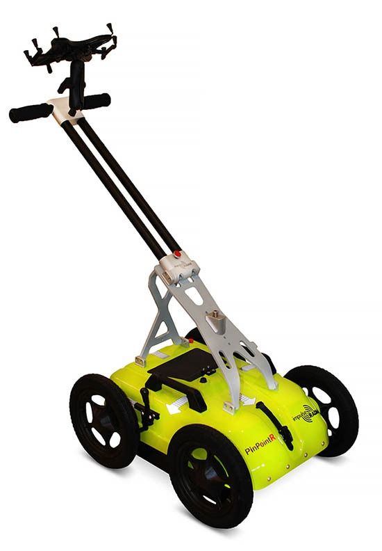
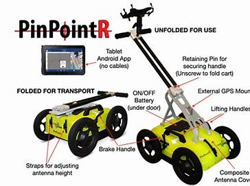
The ImpulseRadar PinPointR is a dedicated GPR utility locator designed for professionals who need accurate subsurface data with minimal setup and maximum reliability.
The PinPointR features dual-channel operation with:
400 MHz (low frequency) for deeper utility detection
800 MHz (high frequency) for shallow detail and improved resolution
This dual-frequency design allows operators to detect both shallow and deep utilities in a single pass, improving efficiency and decision-making in the field.
PinPointR GPR systems operate completely wirelessly, eliminating cable failures and simplifying setup. Data acquisition is controlled through an intuitive Android-based interface, allowing operators to view radar profiles in real time and make immediate locate decisions.
Wireless operation improves:
Field productivity
Equipment reliability
Ease of training and operation
The Android-driven interface provides a familiar, easy-to-learn platform for GPR data collection. Operators can view live radargrams, adjust gain and filters, place markers, and manage projects directly from the touchscreen device.
This approach reduces training time while maintaining advanced functionality required by experienced professionals.
ImpulseRadar GPR systems include internal GPS for geo-referenced data collection. For applications requiring higher positional accuracy, the system supports external DGPS and RTK-GPS integration.
This allows GPR data to be:
Accurately mapped
Exported for CAD and GIS platforms
Used in professional reports and deliverables
PinPointR supports automatic field report generation, helping document site visits and utility investigations. Reports can include radar profiles, markers, and location data, making it easier to provide clear documentation for clients, engineers, and utility owners.
ImpulseRadar GPR data is fully compatible with CrossPoint visualization software for Windows. CrossPoint allows users to process, interpret, and analyze GPR data with tools designed specifically for utility locating applications.
Key capabilities include:
Advanced filtering and processing
Marker visualization on maps
Utility interpretation workflows
Export to CAD and GIS formats
Intermountain Sales is a trusted utility tool distributor with decades of experience supporting water, gas, electric, and communications professionals. When you purchase a GPR system from us, you get more than just equipment.
You get:
Expert product guidance
Application-based support
Training and best-practice recommendations
Long-term service and support
We understand how GPR is actually used in the field — and we help you use it effectively.
Ground Penetrating Radar is a powerful tool when matched correctly to the application. Our team is here to help you determine if GPR is the right solution for your utility locating needs and which system best fits your workflow.
Contact Intermountain Sales today to learn more about our Ground Penetrating Radar systems and schedule a product discussion or demonstration.


Validate your login